 Port Richmond is a neighborhood situated on the North Shore of Staten Island, a borough of New York City. It is along the waterfront of the Kill Van Kull, with the southern terminus of the Bayonne Bridge serving as the boundary between it and Elm Park, the neighborhood which borders it on the west. Formerly an independent village, it is one of the oldest neighborhoods on the island. In the 19th century it was an important transportation and industrial center of the island, but this role has vanished nearly completely, leaving a largely blue collar residential area bypassed by the shift of development of the island to its interior after the 1960s. The formerly bustling commercial center along Richmond Avenue (now Port Richmond Avenue) had been largely abandoned at the time, But in recent years many small businesses have opened in the area with the commercial activity shifting inland to Forest Avenue(or leaving the neighborhood altogether and relocating to the Staten Island Mall when the latter opened in the summer of 1973).
HISTORY
Early exploration and settlement
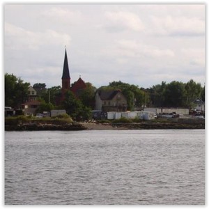
The first white European contact with Staten Island was recorded in 1524 by Giovanni da Verrazzano. In 1609 Henry Hudson established Dutch trade in the area and named the island Staaten Eylandt after the Staten-Generaal, the Dutch parliament. However, it was not until the mid-17th century that a mixed Dutch and French settlement was established at New Dorp. Settlers established a cemetery at nearby Port Richmond, which served as the burial ground for residents of northern Staten Island until 1696. The community of Port Richmond grew up around this cemetery, beginning with the Dutch Reform Church that was built there in the early 18th century. This colonnaded Church, still standing on Port Richmond Avenue was built in 1824 after a fire destroyed the original building. From those Dutch roots, Port Richmond evolved into a thriving waterfront industrial and transportation hub. The village incorporated as Port Richmond in 1866, the same year as the Staten Island villages of New Brighton and Edgewater.
Port Richmond has had many names through the years. In the late 17th century it was known simply as The Burial Place. Subsequently, the area was alternately known as Bristol, New Bristol, Irvington, Cyrene, and Cityville. These names were proposed, but Port Richmond eventually won out in 1866. The name “Port Richmond” was given to the place by Rev. Dr. James Brownlee of the Dutch Reformed Church
In 1700 the area was known as the “burial place” from a cemetery of the Reformed Church on Staten Island near the present Port Richmond Avenue along the waterfront. It later became a transfer point between ferries from New York City toNew Brunswick, New Jersey. A ferry landing (called variously “Ryer’s Landing”, “Mercereau’s Landing”, and “Decker’s Landing”) was later constructed for a route linking Staten Island across the Kill Van Kull to Bergen Point (present-dayBayonne, New Jersey). The Bayonne Bridge was constructed in 1931 yet ferry service continued until 1962.
19th century
Port Richmond’s location on the Kull Van Kill made it a prime ferry launch from Staten Island to New Jersey. It was a transfer port for freight and passengers traveling by boat between New York City and New Brunswick, New Jersey. This point is the part of Staten Island closest to Port Elizabeth, New Jersey and was once called Mersereau’s Point, after Mersereau’s Ferry. This point was also known as Lambert’s, Collyer’s, and Bowman’s Point. It was called Lambert’s Point during the Revolutionary War and later Collyer’s Point. Other ferries that operated from that point were: Dacosta’s, Indian, Decker’s, Ryers’, and Hilleker’s. Ryers’ and Hilleker’s ferries were in competition with one another until David Mersereau bought out both companies in the late 19th century. Ferries ran continually until shortly after the Bayonne Bridge was built in 1931. The area also became the site of an important stop on a coach route between the city and Philadelphia. Port Richmond Avenue has been known over the years as Church Road, Port Richmond Plank Road, Stone Road, and Richmond Avenue. The road is a continuation of an old highway called the Morningstar Road.
Cornelius “Commodore” Vanderbilt, railway tycoon and patriarch of the Vanderbilt family, was born in the area in 1797. In 1836, former Vice President Aaron Burr died in Port Richmond at the St. James Hotel, a prominent hotel which once stood on Richmond Terrace until it was demolished.
In the early 19th century, the area was an overnight coach stop between New York City and Philadelphia. In 1836, a public park was built. In the middle 19th century, the area began to attract immigrants from Ireland and Germany. Among the industries established in the area was the only whale oil processing plant on Staten Island. It was later replaced by a linseed oil processing plant that operated until the 20th century. Other industries included lumber andcoal yards, as a dye processing plant. Because oyster harvesting was a booming business along the mudflats in New York Harbor, many successful oyster boat captains built mansions on Richmond Terrace facing the Kill van Kull in the 1840s and 1850s. Industries along the waterfront included lumber and coal yards.
In 1883, Port Richmond was described as a model village:
The general appearance of Port Richmond is inviting and pleasing.
The streets are wide, well-macadamized and smooth; the side walks well paved and generally shaded by trees of large growth. The business blocks are substantial and the dwellings range from pretentious mansions to quiet cottage
In 1866, the neighborhood was incorporated as Port Richmond. In the 1880s, the Staten Island Railway constructed a North Shore branch with a stop in the village on Richmond Avenue, which had become a main shopping area of the island. In the 1870, St. Philip’s Baptist Church, the oldest of the three black Baptist congregations on the Island, was formed. The church still stands at 77 Bennett Street, right next door to the Port Richmond Library. At the beginning of the 20th century, it attracted large numbers of Italian, Polish, Norwegian, and Swedish immigrants. A public library was built with funds from Andrew Carnegie in 1902.Temple Emanu-El erected its domed, Classical building in 1907.
20th century
When telephone service was upgraded in New York City in December 1930, a telephone exchange bearing the designation “Port Richmond 7” was created, its territory including the neighborhood itself along with many other communities on the western and central North Shore plus the island’s then-sparsely populated, rural interior. This exchange was disconnected in 1948 when a “Port Washington 7” exchange was established to serve the town by that name in Nassau County, onLong Island; the Port Richmond exchange’s customers were then moved to exchanges that heretofore had been found to the east, such as “Saint George 7.”
The neighborhood suffered a severe economic decline in the latter half of the 20th century, largely as a result of the shift of development and commercial activity to the center of the island, following the construction of the Verrazano-Narrows Bridge. The North Shore Branch of the Staten Island Railway that ran through the neighborhood connecting it to St. George was mainly a freight railroad. It was owned by the Baltimore and Ohio Railroad and was briefly, in 1925 and 1926, used as a passenger service link to the ferry launch at St. George. This was suspended as the boat ride was slower than the trip usual B & O trip to its usual terminal at the CNJ Terminal in Jersey City, New Jersey. During World War II some trains were used to move troops. This branch was closed in 1953, leaving behind a dilapidated track and Port Richmond station along Richmond (now Port Richmond) Avenue. Plans for reopening this line were studied at various times during the 1990s and early 2000s as a Staten Island light rail line.
DEMOGRAPHICS
As of the 2010 census, the demographics of Port Richmond were roughly 26.7% White, 21% Black, 45.7% Hispanic, 3.7% Asian, 3.9% Other. The Black and Latino populations are largest in the northern section of the neighborhood, near Richmond Terrace. The southeastern portion of the neighborhood (roughly south of Post Avenue & east of Port Richmond Avenue) is the section with the largest percentage of Whites (almost 50%), and is sometimes referred to as “Port Richmond Center” or “Upper Port Richmond”.
The median household income in the neighborhood is roughly $45,000 a year. This is defining Port Richmond as everything within the boundaries of Census Tract 207, 213, and 247, as well as Block Group 1 of Tract 201.
The 10302 zip code (which is mostly Port Richmond, but also includes part of Westerleigh) has the highest percentage of Hispanics of any zip code on Staten Island, at 41.3%. Within the Hispanic population, it is the only zip code on Staten Island where Mexicans outnumber Puerto Ricans: Mexicans make up 20% of the population of the zip code. The zip code includes parts of nearby Westerleigh, so Mexicans make up roughly 23% of the population of Port Richmond, with the presence being highest along Port Richmond Avenue, and in the northern part of the neighborhood in general.
Crime
Port Richmond has long been plagued by high levels of crime, such as prostitution, drugs and violence.However, much of it takes place in the northern part of the neighborhood, north of roughly Post Avenue.
In 2009, findings showed that Port Richmond (zip code 10302) received a 7 on a scale of 1-10 in terms of violent crime level – the highest for any zip code on Staten Island (one other Staten Island zip code also received a 7). The United States violent crime average for a zip code is a 3.
Port Richmond also received a 6 on an identical scale measuring property crime. The United States property crime average for a zip code is also a 3.
Racial tensions between blacks and Hispanics
The African-American community that had long occupied Port Richmond’s Northern quarters began to see a large influx of Mexican immigrants move in alongside them starting late in the 1980s. The Mexicans transformed many boarded up storefronts along Port Richmond Avenue and quickly made the commercial strip the center of Latino culture on Staten Island. Still many of Port Richmond’s Mexicans line busy neighborhood streets every morning looking to be picked up for work as day laborers. Since they often commute on foot and usually have money in their pockets, the immigrants have long been targeted for violent muggings and senseless attacks on Port Richmond streets. The tensions between the area’s long-time inhabitants and its newcomers have been well documented for years. Several outreach groups have since popped up to address the community’s issues. Still, mistrust persists on both sides of the fence, as portions of northern Port Richmond (especially west of Port Richmond Avenue) have shifted from being predominantly Black to predominantly Hispanic.
This led to an incident, whence in the early morning hours of April 5, 2010, 26-year old baker Rodulfo Olmedo was on his way home from a local club on Port Richmond Avenue when he was set upon by three African-American and one Hispanic teenagers, who badly beat Olmedo with unidentified objects believed to be baseball bats or wooden planks and possibly a chain before robbing his unconscious body of cash and a cellphone. After being helped by a passer-by and brought to the hospital, Olmedo, a 13-year resident of the U.S., told police that throughout the attack, which was captured on nearbysurveillance cameras, he was verbally discriminated against. The attack provoked outrage both politically and locally, but while many felt the attack was solely a result of the victim’s nationality, the attackers insisted that they knew Olmedo and were merely settling an earlier score with him. Regardless, the incident caused similar but unpublicized incidents, which had been taking place, to be publicized.After the incident, the United States Department of Justice began assisting community officials in their efforts to develop a neighborhood watch or a “Crime Response Team”, a group of citizens that would possibly work with the NYPD to report suspicious activity and prevent more violence in the neighborhood, as well as to organize a series of meetings to facilitate community dialogue. They also set out to create “safe spaces”, which was not the first time the idea was floated. These are willing businesses that are open late, such as bodegas or delis, where people who feel like they are being followed or otherwise fear for their safety, can seek refuge and be assisted by workers with contacting the police.