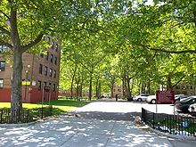
 Gravesend (pronounced GRAVE’S end, not grave SEND) is a neighborhood in the south-central section of the New York City borough of Brooklyn, USA.
The derivation of the name is unclear. Some speculate that it was named after the English seaport of Gravesend, Kent. An alternative explanation suggests that it was named by Willem Kieft for the Dutch settlement of “‘s- Gravesande”, which means “Count’s Beach” or “Count’s Sand”. There is also a town in the Netherlands called ‘s-Gravenzande.
Gravesend was one of the original towns in the Dutch colony of New Netherland and became one of the six original towns of Kings County in colonial New York. It was the only English chartered town in what became Kings County and was designated the “Shire Town” when the English assumed control, as it was the only one where records could be kept in English. Courts were removed to Flatbush in 1685. The former name survives, and is now associated with a neighborhood in Brooklyn. Gravesend is notable for being founded by a woman, Lady Deborah Moody; a land patent was granted to the English settlers by Governor Willem Kieft, December 19, 1645. A prominent early settler was Anthony Janszoon van Salee.
Gravesend Town encompassed 7,000 acres (28 km²) in southern Kings County, including the entire island of Coney Island, which was originally the town’s common lands on the Atlantic Ocean, divided up, as was the town itself, into 41 parcels for the original patentees. When the town was first laid out, almost half were salt marsh wetlands and sandhill dunes along the shore of Gravesend Bay.
As of 2007, Gravesend had a population of 181,651.
HISTORY
The first known European to set foot in the area that would become Gravesend was Henry Hudson, whose ship, the Half Moon, landed on Coney Island in the fall of 1609. The island and its environs were at that time inhabited by five Native American tribes—the Narriockh, the Mannahanning,the Massebackhun, the Morpeesah, and the Makeepaca. To them the area was known as Savanehachee, “the sea-bounded plain.”
The land subsequently became part of the New Netherland Colony, and in 1643 it was granted to Lady Deborah Moody, an English expatriate who hoped to establish a community where she and her followers could practice their Anabaptist beliefs free from persecution. Due to clashes with the local native tribes the town wasn’t completed until 1645. But when the town charter was finally signed and granted it became one of the first such titles to ever be awarded to a woman in the new world.
The town Lady Moody established was one of the earliest planned communities in America. It consisted of a perfect square surrounded by a 20-foot-high wooden palisade. The town was bisected by two main roads, Gravesend Road (now McDonald Avenue) running from north to south, and Gravesend Neck Road, running from east to west (Map). These roads divided the town into four quadrants which were subdivided into ten plots of land each (The grid of the original town can still be seen on maps and aerial photographs of the area). At the center of town, where the two main roads met, a town hall was constructed where town meetings were held once a month.
The religious freedom of early Gravesend made it a desirable home for many ostracized or controversial groups, such as the Quakers, who briefly made their home in the town before being chased out by New Netherland governor Peter Stuyvesant, who was wary of Gravesend’s open acceptance of “heretical” sects.
In 1654 the people of Gravesend purchased Coney Island from the local natives for about $15 worth of seashells, guns, and gunpowder.
